Trail Walking Les Thuiles - Lac d'Aupillon  - Photo
 nadd73
nadd73

User

© OpenStreetMap contributors
Length
Length
8.1 km
Max alt
Max alt
2545 m
Uphill gradient
Uphill gradient
507 m
Km-Effort
Km-Effort  
14.8 km
Min alt
Min alt
2051 m
Downhill gradient
Downhill gradient
505 m
Boucle
Boucle
Yes
Creation date :
2022-08-04 08:01:49.474
Updated on :
2022-08-04 12:55:43.615

(0 Reviews)

Walking
Walking
2h24
Difficulty : Medium

Scan this QR Code to open this trail in the SityTrail application

FREE GPS app for hiking

Logo SityTrail SityTrail

IGN / Geographical institutes

Download SityTrail from the App Store Download SityTrail from Google Play

Logo SityTrail SityTrail World

The world is yours!

Download SityTrail from the App Store Download SityTrail from Google Play Download SityTrail on Huawei AppGallery

About

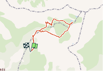
Trail Walking of 8.1 km to be discovered at Provence-Alpes-Côte d'Azur, Alpes-de-Haute-Provence, Les Thuiles. This trail is proposed by nadd73.

Description

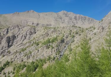
Le chemin de Borel à Les Hieres n'est pas toujours en bonne état mais ça passe.
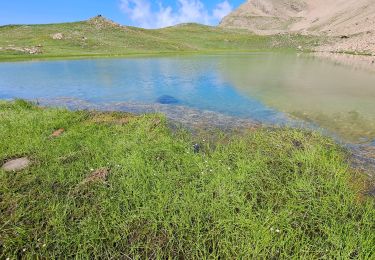
Je l'ai fait dans ce sens car la montée est plus facile que la descente qui est plus raide. Le lac, à ce jour est sec 😕.
Donc pas de baignade 😉.

Elevation profile

Photos

Positioning

Country:
France
Region :
Provence-Alpes-Côte d'Azur
Department/Province :
Alpes-de-Haute-Provence
Municipality :
Les Thuiles
Location:
Unknown
Start:(UTM)
305494 ; 4922337 (32T) N.

Trails nearby

Trail Walking Les Orres - le pic de Boussolenc par la tête du vallon Rémollon - Photo
Walking
GUIDE
amiral13

Walking

Medium
(1)
Les Orres, Provence-Alpes-Côte d'Azur, Hautes-Alpes, France
7.7 km | 13.7 km-effort
4h 50min
Yes
Trail Walking Les Thuiles - les Thuiles/les pras - Photo
Walking
andre06130

Walking

Difficult
(1)
Les Thuiles, Provence-Alpes-Côte d'Azur, Alpes-de-Haute-Provence, France
9.6 km | 16.3 km-effort
3h 42min
Yes
Trail Mountain bike Méolans-Revel - tour au sud de Méolans - Photo
Mountain bike
andre06130

Mountain bike

Medium
(1)
Méolans-Revel, Provence-Alpes-Côte d'Azur, Alpes-de-Haute-Provence, France
15.9 km | 24 km-effort
1h 40min
Yes
Trail Walking Saint-Pons - chemin de la Chalanche et crête des Cognetons - Photo
Walking
andre06130

Walking

Very easy
(2)
Saint-Pons, Provence-Alpes-Côte d'Azur, Alpes-de-Haute-Provence, France
6.4 km | 11.4 km-effort
1h 44min
Yes
Trail Walking Les Thuiles - lacs et Col de l'Aupillon. 13/07/23 - Photo
Walking
Dervalmarc

Walking

Medium
Les Thuiles, Provence-Alpes-Côte d'Azur, Alpes-de-Haute-Provence, France
52 km | 118 km-effort
5h 35min
No
Trail Touring skiing Les Thuiles - Les Plastres - Photo
Touring skiing
GUIDE
David25400

Touring skiing

Medium
Les Thuiles, Provence-Alpes-Côte d'Azur, Alpes-de-Haute-Provence, France
13.4 km | 26 km-effort
4h 38min
Yes
Trail Walking Les Thuiles - L'Aupillon - Photo
Walking
GUIDE
David25400

Walking

Medium
Les Thuiles, Provence-Alpes-Côte d'Azur, Alpes-de-Haute-Provence, France
16 km | 31 km-effort
6h 48min
Yes
Trail Walking Saint-Pons - Col de la Pare.Sentier Horizontal. Refuge de la Pare/02/08/21 - Photo
Walking
Dervalmarc

Walking

Medium
(1)
Saint-Pons, Provence-Alpes-Côte d'Azur, Alpes-de-Haute-Provence, France
18.3 km | 34 km-effort
11h 47min
Yes
Trail Walking Les Thuiles - Les Plastres - Lac de l'Aupillon - Photo
Walking
GUIDE
David25400

Walking

Medium
Les Thuiles, Provence-Alpes-Côte d'Azur, Alpes-de-Haute-Provence, France
12.3 km | 24 km-effort
4h 21min
Yes


Close
My subscriptions